Los Angeles put cameras on roughly 900 trash trucks and fed the footage into computer vision models. That is a serious deployment at a serious scale, and it deserves credit. It turns existing fleet hardware into a detection network, it improves on a manual survey cycle that used to take six to eight weeks, and it gives crews better information than a phone report ever could.
But it is worth being precise about what that system is and is not. Truck-mounted cameras are a street-level sensing system. They detect what a camera can see from the curb, on the route the truck happened to drive, on the day the truck happened to drive it. That is a genuinely useful tool. It is not the same thing as knowing where the illegal dumping is.
Here are the five reasons.
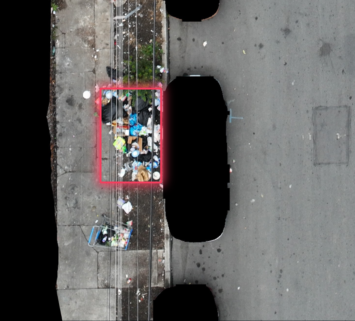
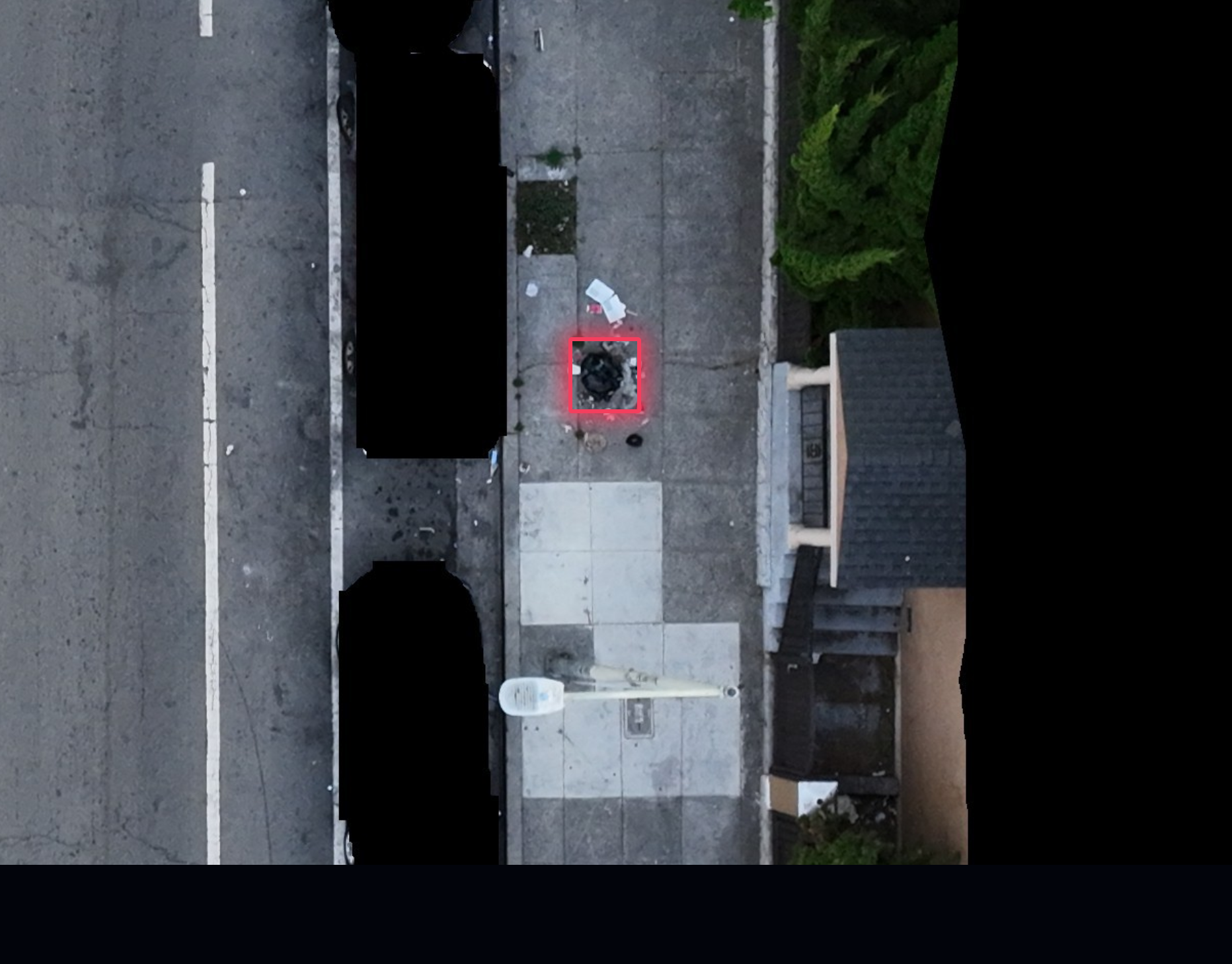
Most of the garbage is hidden behind parked vehicles
Illegal dumping in a residential neighborhood accumulates where people actually live: along the curb, in front of houses, under trees, in driveway aprons, behind cars. A camera mounted on a truck looks down the street from a low angle. The first thing it sees is a row of parked vehicles.
Those vehicles block the line of sight to the sidewalk and the property edge behind them. A bag of household waste, a pile of construction debris, a mattress, a cluster of furniture: most of it sits directly behind or between parked cars, which means the camera sees a car and not the trash. The detection never fires, so the pile never becomes a work order, so no crew ever goes.
This is not an edge case. On a residential street with legal parking on both sides, the fraction of curbside space visible from a vehicle-height camera is small. Dumping that sits behind a single parked van is invisible for as long as the van is there. Because illegal dumping frequently persists for weeks, the same pile can be invisible on every single pass.
Tree cover and street furniture block the view too
Where parked cars don't block the line of sight, the city's own streetscape does. Street trees, canopies, hedges, utility poles, parked trailers, construction fencing, and large bins all sit between a ground-level camera and the ground behind them. A pile tucked under a mature tree canopy, against a fence line, or behind a row of parked trailers is exactly the kind of low-visibility dumping that residents report and crews struggle to find.
An aerial camera doesn't solve this by being smarter. It solves it by changing the geometry. Flying at altitude with an angled look means the model sees into the space under and between the obstructions, from multiple angles in a single pass, rather than trying to see through them from the curb.
Ground-level GPS is unreliable, and the truck's position isn't the pile's position
Positioning at street level is hard. Urban canyons, dense building coverage, and repeated satellite occlusion degrade a standard GPS fix, and a refuse truck is a worst-case receiver: it sits low, in the shadow of buildings, driving under trees and structures, often with a metal body and roof-mounted equipment that degrades the signal further. The result is position jitter and dropouts along exactly the routes where coverage matters most.
There's a second, bigger problem. Even a perfect GPS fix on the truck only tells you where the truck was. The garbage is on the sidewalk or the property edge, off to the side of the travel lane, sometimes several meters away. In dense blocks that offset is enough to place a detection on the wrong property line or the wrong side of the street. At street level, that error is measured in meters, and meters are the difference between "the pile at 85th and San Pablo" and "the pile somewhere on the adjacent block."
A drone flying with RTK/PPK correction gets centimeter-level positioning on the target itself, because the target's coordinates come from the imagery, not from where the platform happened to be.
Garbage trucks don't drive every road, and they don't drive any road every day
This is the constraint that quietly caps everything else. Collection routes are designed around where garbage is generated and how much the city can afford to drive, not around where dumping might be occurring. Alleys, vacant lots, dead ends, creeks, rail rights-of-way, and the interior of large parcels don't appear on a refuse route at all, because there is no pickup to make there.
And where a truck does go, it goes on a fixed weekly schedule. That means a given street is observed maybe once a week, at best. A pile dropped on Tuesday may sit unseen for six days. A pile dumped on Friday may be gone before the next pass, or may be visible only after it has already been there long enough to draw another pile. If the truck's route shifts that week, the street might not be observed at all.
So the honest description of truck camera coverage isn't "the city is monitored." It's "a subset of the city's streets is sampled roughly weekly, from a fixed vantage point, on a fixed schedule." That's a survey program. It's a good one. It isn't complete coverage.
Hundreds of cameras means hundreds of failure points
This is the part that gets underestimated. A truck-mounted network isn't one camera. It's dozens or hundreds of independent cameras distributed across dozens or hundreds of independent vehicles, each one with its own lens, housing, mount, power connection, cable run, network radio, and storage device.
Every one of those is a failure point. A mount loosens. A lens gets dirty from road spray and dust and stays dirty because the truck goes through a wash bay that doesn't cover the sensor. A cable corrodes. A radio drops in a specific dead zone. A camera reboots and comes back with the wrong timestamp. A truck goes out of service for a repair and its camera goes dark for two weeks. Detection quality degrades quietly in all of these cases, and because the failure is silent, the data looks fine, just thinner.
Compare that to an aerial system. One airframe, one stabilized camera payload, one RTK/PPK GPS, one onboard computer, one operator. If something needs maintenance, it's one platform and one crew. The coverage per unit of failure is dramatically higher, and the whole detection stack is centralized rather than distributed across a fleet.
The Failure Points Add Up
Here is the thing about a truck-mounted network: the limitations aren't independent, they compound. A camera behind a parked car sees nothing. If that street is only driven weekly, the nothing persists for a week. If the truck's GPS jitters at that point, even a successful detection is mislocated. And because the camera itself might be dirty or disconnected that week, the detection might not have happened at all.
Each of those alone might be tolerable. Together, they describe a system with a low, uneven, and largely unmeasured probability of catching any given pile on any given day, in a subset of the city, on a schedule the city doesn't control.
And then there's the volume problem, which follows from the geometry. A ground-level camera can see that something is there. It cannot reliably tell you whether that's one bag or three cubic yards of construction debris, because it's a 2D image from a single low angle. So even when a truck camera does fire, the output is a detection without a size. Cities that build work orders on that output still have to send somebody to look.
What Aerial Detection Changes
None of this makes truck cameras useless. They are excellent at one thing: capturing the street-level view of routes you're driving anyway. If a city wants a cheap, low-friction signal on its existing collection routes, it's a good program. The question is what you build on top of it.
Aerial detection changes the sensing geometry rather than the route schedule, and it changes the economics of the hardware at the same time.
| What the system needs | Truck-mounted camera | Aerial detection |
|---|---|---|
| See past parked vehicles | No. Cars are a hard occlusion from the curb | Yes. Angled look from altitude clears vehicle height |
| See under tree canopy | No. Canopy blocks the view entirely | Yes. Multi-angle look sees into the space beneath |
| Position accuracy | Meter-level, and degraded in urban canyons | Centimeter-level via RTK/PPK on the target |
| Frequency | Fixed route, roughly weekly | As often as the mission requires |
| Geographic reach | Only where trucks already go | Anywhere a legal, safe coverage plan allows |
| Pile size | 2D image from a single low angle | Multi-angle imagery supports volume estimates |
| Failure points | Dozens to hundreds, distributed across a fleet | A small number of centralized platforms |
| Maintenance model | Fleet-wide, continuous, per-vehicle | Per-platform, scheduled, consolidated |
The core difference
A truck-mounted camera system surveys the routes the city already drives. An aerial system observes the city. One inherits the blind spots of the collection schedule; the other is designed around the coverage requirement. For a city that needs complete, current, geolocated knowledge of where dumping is, that's the difference between a program and a system.
Why This Matters for Work Orders
All of the above lands hardest at the point where a detection becomes a work order, because a work order is a promise to send a crew to a specific place for a specific reason. If the detection has no reliable coordinates, the crew searches the block. If the detection has no size, the crew may arrive with the wrong equipment and need a second trip. If the detection never happened because a pile was behind a van, the crew never comes at all and the pile grows.
That is why the difference between a survey system and a coverage system shows up in the operating budget, not just the analytics. A truck camera network produces a partial picture that requires human follow-up to become actionable. An aerial system produces a complete picture that's already actionable, because it verifies presence, location, and size in the same pass.
We think the cleanest way to think about it is this: cameras on garbage trucks tell you where the city's waste is. That's a real and valuable signal, and it's not the same as knowing where the city's illegal dumping is.
Sources & Methodology
This article assesses sensing limits inherent to truck-mounted camera systems and how they compound into incomplete coverage. It does not claim that truck cameras are a poor deployment. They are a good deployment for what they can see. The argument is about what a city can and cannot build on top of them.